


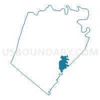
Voting District 35, Berkeley County, West Virginia
About
Outline

Summary
| Unique Area Identifier | 690331 |
| Name | Voting District 35 |
| County | Berkeley County |
| State | West Virginia |
| Area (square miles) | 6.94 |
| Land Area (square miles) | 6.94 |
| Water Area (square miles) | 0.00 |
| % of Land Area | 100.00 |
| % of Water Area | 0.00 |
| Latitude of the Internal Point | 39.39173440 |
| Longtitude of the Internal Point | -77.95961120 |
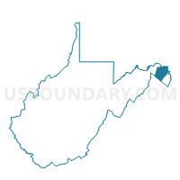
Maps

Graphs
Select a template below for downloading or customizing gragh for Voting District 35, Berkeley County, West Virginia


Neighbors
Neighoring Voting District (by Name) Neighboring Voting District on the Map
- Voting District 24, Berkeley County, WV
- Voting District 25A, Berkeley County, WV
- Voting District 26, Jefferson County, WV
- Voting District 31, Berkeley County, WV
- Voting District 37, Berkeley County, WV
Top 10 Neighboring County Subdivision (by Population) Neighboring County Subdivision on the Map
- Shenandoah district, Berkeley County, WV (21,115)
- Tuscarora district, Berkeley County, WV (20,830)
- Middleway district, Jefferson County, WV (9,353)
Top 10 Neighboring Unified School District (by Population) Neighboring Unified School District on the Map
Top 10 Neighboring State Legislative District Lower Chamber (by Population) Neighboring State Legislative District Lower Chamber on the Map
Top 10 Neighboring State Legislative District Upper Chamber (by Population) Neighboring State Legislative District Upper Chamber on the Map
Top 10 Neighboring 111th Congressional District (by Population) Neighboring 111th Congressional District on the Map
Top 10 Neighboring Census Tract (by Population) Neighboring Census Tract on the Map
- Census Tract 9720, Berkeley County, WV (11,756)
- Census Tract 9719, Berkeley County, WV (9,879)
- Census Tract 9721.02, Berkeley County, WV (9,710)
- Census Tract 9723, Jefferson County, WV (4,516)